
An inertial navigation system (INS) is a navigation device that uses motion sensors (accelerometers), rotation sensors (gyroscopes) and a computer to continuously calculate by dead reckoning the position, the orientation, and the velocity (direction and speed of movement) of a moving object without the need for external references. Often the inertial sensors are supplemented by a barometric altimeter and sometimes by magnetic sensors (magnetometers) and/or speed measuring devices. INSs are used on mobile robots and on vehicles such as ships, aircraft, submarines, guided missiles, and spacecraft.
How does an inertial navigation system work?
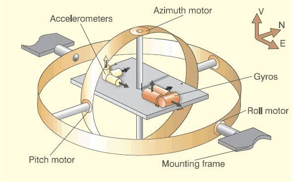
An inertial navigation system works by measuring the acceleration and rotation of a moving object. The accelerometers measure the object’s acceleration in three axes: up/down, left/right, and forward/back. The gyroscopes measure the object’s rotation in three axes: pitch, yaw, and roll.
The computer in the INS uses the data from the accelerometers and gyroscopes to calculate the object’s position, orientation, and velocity. The computer does this by integrating the acceleration data over time to calculate the object’s velocity, and then integrating the velocity data over time to calculate the object’s position.
The INS also uses a barometric altimeter to measure the object’s altitude. The barometric altimeter measures the air pressure at the object’s current location and uses this information to calculate the object’s altitude.
Advantages of inertial navigation systems
Inertial navigation systems have several advantages over other navigation systems, such as GPS. INSs are not affected by interference from radio waves or other electromagnetic signals, so they can be used in areas where GPS is not available, such as inside buildings or in tunnels. INSs are also very accurate, and they can maintain their accuracy even over long periods of time.
Disadvantages of inertial navigation systems
Inertial navigation systems also have some disadvantages. One disadvantage is that they can be expensive. Another disadvantage is that they can drift over time, so they need to be periodically updated with information from other navigation systems, such as GPS.
Applications of inertial navigation systems
Inertial navigation systems are used in a wide variety of applications, including:
- Aircraft navigation
- Ship navigation
- Submarine navigation
- Guided missiles
- Spacecraft navigation
- Robot navigation
- Virtual reality
Future of inertial navigation systems
The future of inertial navigation systems is bright. As technology continues to improve, INSs will become more affordable and accurate. This will make them even more widely used in a variety of applications.